
Floridians breathed a guarded sigh of relief Saturday as it appeared the Sunshine State may be getting ready to dodge a major bullet with Hurricane Dorian.
More than 100 linemen from O’Connell Electric Co. in Syracuse, N.Y. have arrived in The Villages in anticipation of Hurricane Dorian. More than 50 power company trucks on Saturday were using the parking lot at Wal-Mart at Buffalo Ridge Plaza as a staging area. The lineman said another 20 trucks are making the 18-hour drive from New York.


These linemen are slated to join 30,000 Florida linemen in responding to possible damage inflicted by Hurricane Dorian. Bucket trucks were also rented from an Indiana company and were in the staging area at Buffalo Ridge Plaza.
The latest projection for the Category 4 hurricane shows it turning north and remaining in the Atlantic Ocean as it skirts the east coast of Florida. That scenario would still result in some potentially high winds and a few inches rain for The Villages and the surrounding tri-county area, but nothing like the earlier predictions when the storm was forecast to either come ashore near Daytona Beach and blast the local area or roar into the Sunshine State near Vero Beach/Fort Pierce, turn north and move up the center of Florida.

Forecasters, however, are still reminding area residents that the projections for Dorian’s path are still quite fluid and could change in a moment’s notice. And at the very least, they say there’s a good chance of tropical storm-force winds hitting the area as the storm roars north and possibly targets the Carolinas for landfall.
Dorian is expected to lash the Bahamas sometime Sunday, where some computer models have it stalling and dumping as much as 50 inches of rain before moving away from the islands. Residents there are being warned of storm surges that could be 15 feet above normal tide level with large and destructive waves.
Gov. Ron DeSantis on Saturday encouraged Floridians to continue to keep a close eye on Hurricane Dorian, saying the state is far from being out of danger. While he said the narrowing of the cone of uncertainty for the hurricane’s path will help with deploying resources, he reminded residents that there’s still a strong possibility of high winds, rain and coastal flooding – even if the storm remains offshore.
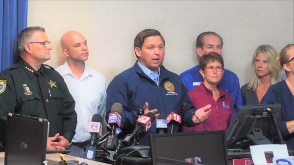
“I would remind people, as you’re looking at these forecasts, a bump in one direction or the other could have really significant ramifications in terms of impact,” he said. “If it bumps further east, that obviously is positive. If it bumps just a little west, then you’re looking at really, really significant impacts.”
DeSantis said he spoke with President Trump and the state continues to have his full support. The president met with FEMA officials on Saturday at Camp David to discuss the response to the hurricane and is being briefed hourly on the storm.
Likewise, DeSantis vowed to continue monitoring Dorian closely over the next several days. And he encouraged anyone living in areas in the storm’s cone of uncertainty to remain prepared for a possible worst-case scenario.

“There is still a significant chance of a strike on the state of Florida,” he said.
Locally, the Marion County Sheriff’s Office, in its capacity as an emergency management agency, said the latest predictions are for the county to receive 3-4 inches of rain as the storm moves up the coast – a far cry from the 20-inch prediction the county was facing a few days ago. There are no plans to open shelters, but the resources are in place to do so quickly, officials say.
In Marion County, sandbag locations will remain open through Sunday from 7 a.m. to 7 p.m. Bags, sand, and shovels are provided free. County residents can pick up their sandbags at:
- Belleview Sports Complex, 6501 SE 107th St., Belleview;
- Dunnellon City Complex, 11924 Bostick Street, Dunnellon;
- Wrigley Field, 405 County Road E 316, Citra;
- East Marion Sports Complex – 14445 NE 14th Street Road, Silver Springs.
Ocala residents can get sandbags at:
- Reilly Arts Center, 500 NE 9th St., Ocala;
- Ed Crosky Recreation Center, 1510 NW Fourth St., Ocala.
In Lake County, residents can pick up sandbags over the weekend from 7 a.m. to 7 p.m. at:
- Solid Waste Residential Convenience Center, 1200 Jackson St., Lady Lake;
- Fire Station 10, 23023 State Road 40, Astor;
- Fire Station 14, 18840 County Road 42, Altoona;
- Fire Station 39, 31431 Walton Heath Ave., Sorrento; and
- Fire Station 110, 6234 County Road 561, Clermont.
Emergency management agencies in Lake, Marion and Sumter County still are encouraging residents to sign up for alerts about weather and other pertinent situations. To sign up for AlertLake, click HERE. To sign up for AlertMarion, click HERE. To sign up for AlertSumter, click HERE.